
People often ask me why I chose to come to Tasmania. Not least of all, Tasmanians. While the immediate reasons are relatively straight-forward (not sure where I wanted to be; was busy arranging time in Liberia when my Residency classmates were looking for jobs; thought "why not go overseas?" and not all that confident in my Spanish; signed up w/ an agency and was given a few choices), there is more to it than "why not?" In fact, I think that quite a few Tasmanians suffer from the "Statue of Liberty" phenomenon, in that if you are from a place you rarely end up doing the things that tourists do when they come to that place. For Tasmania, the "touristy things" are amazing opportunities for "bushwalking" (camping/hiking) and exploring the wilderness that is relatively untouched.
Much like my home state of West Virginia, the preservation of the wild is the positive that often (though not always and usually not without someone to fight for it!) comes with relative under-development. In fact, I find myself telling people here that I felt comfortable coming to this town in northern Tasmania specifically because it was similar to the town I grew up in back home in West Virginia. Go Big Reds.
With that as an introduction, I have on my refrigerator a list of goals for Tasmania. In addition to "improve posture," "drink two glasses of water a day," "run 9.30 min mile for 1/2 marathon," "normalize TSH level" and "Sort out life direction," on that slip of paper there is also the aspiration-- "Walk the Overland." Well, the TSH may be coming along, but the only one I've been able to cross off so far has been that last. And thank goodness for that.
The Overland Track is one of Australia's and certainly Tasmania's most famous walks. Similar to the Appalachian Trail in the States but perhaps more isolated, the track starts in the Cradle
Mountain National Park and makes its way south through the World Heritage area for 65 kilometers to end at Lake St. Clair. A lot of my pictures from the trip are also up on my Facebook page, but I thought I'd try to put some up here along w/ a little bit of context.
First off, the Players. Myself and my girlfriend YoungJoo started off in the morning, leaving my flat in West Launceston, loaded up and ready for adventure. Naturally she felt the need to bring along a tiny toy stuffed possum...
As with all great adventres, we first made our way to that most exotic of locales, the bus stop:
.JPG)
While game and having been on a few hikes w/ me previously, Youngie hadn't really done any extended camping or bushwalking at all before. This prompted the following photo in which I point out what is on my mind and the lack thereof once we actually get on the trail...

During the popular season in Dec-Jan-Feb-March (aka summer), the trail can only be hiked North to South. So we had to convoy down to the end at Lake St. Claire the night before, leave one of our cars, and carpool back. Because of the length of the drive, we ended up driving back in the evening, leading to the maiming of several species of Australian wildlife and the front end of my 98 Toyota Camry (anyone in Tassie in the market?)

The Track itself was fantastic and we got off to a pretty good start, crossing Cradle Valley and heading up to Marion's lookout, the face track to Cradle Mountain, and getting in to Waterfall Valley Hut on the first day.
This is a view of Crater Lake from the Overland Track on the way to Marion's Lookout, day 1.

Climbing up to Marion's Lookout, and then standing on it w/ Cradle in the background:


.JPG)
The last is Cradle Mountain as seen from the Cradle Plateau, "just" after Marion's Lookout.
To be honest things began to blur together a bit as to which day was when or where. And every time I stopped to use the camera I kept thinking of that line from Desert Solitaire where he exorts the tourists to
see what is in front of them as opposed to trying to compose a picture about it. But here are a few shots, regardless. I recall one of the Parks and Wildlife workers mentioning that 60% of the species found in the world heritage area are found nowhere else (which explains the planked boardwalk!). Quite a few of the areas on the Cradle Plateau reminded me of the algific talus slope we saw in West Virginia as part of the Mountain Institute. A giant outcrop collapsed and buried a glacier underneath it, trapping and insulating the ice and leading to tundra-type flora in the middle of the Appalachians! :)


There were fair amounts of myrtle and deciduous forest as well, especially on our day 2 marathon!

Buttongrass alongside the track, day 1 or 2. I'd thought it had gotten it's name from the clumps in which it grows, but apparently the button-like appearance of the flowers is responsible. I didn't see any flowers-- I like my reason.

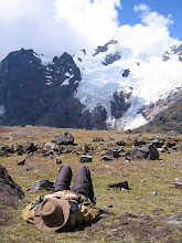
Here is the trail to Mt. Ossa at Pelion Gap, day 3. We left our l

arge packs at the trailhead and spent aobut 4 hours climbing up to the top of Ossa, which is Tasmania's highest point and often snow covered even in early summer. The climb was a bit challenging in parts but not technical. There were certainly a few traverses where you thought to yourself, "I'm doing this on purpose?" Managed to get sunburned in spite of the sunscreen on this one. This is why bald guys like the big hats! :(
A side trip on day 4 took us to Fergusson Falls, just 2km North of DuCane Gap. A very nice Frenchman took our photo. I was of course envious in that he had two trekking poles and I only the one I'd borrowed from a friend of Youngie's. I am happy to say that one birthday later I now have a set of my own poles.

It was interesting in that at the trailhead to Mt. Ossa, it was this guy's pack that the crows had un-zipped and gotten into. By watching hikers from afar over time, the crows learned that food was in the packs and had worked out how to unzip them with their beaks!

It finally rained on us day 3 and 4. It's only fair-- the area we were hiking through at the time was temperate rainforest-- similar to the Pacific Northwest or cloud producing forests like Monteverde in Costa Rica, perhaps.
Here, in the distance you can just make out Young on the track, surrounded by enormous gum trees. This was day 4 or so.
Day 5 we hit the suspension bridge over the Narcissus River on our way to Lake St. Clair.
A fair number of features in the area have names derived from ancient Greece. I think it started with an area termed "the Labyrinth" and people just kept it up from there. I particularly enjoy the warning sign...
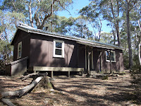
We ended up having a spot in each of the huts we came across, so never had to use the tent we brought. But at least one couple in the group we started out with did get caught between huts and ended up using theirs, so it's definitely worth it to have one available. This is Narcissus hut, which is the last one we came across. It's certainly not the nicest, as some of them were amazing, especially considering there's nothing else around.

So this is me scratching my head at Narcissus after summoning the ferry to take us out. You can either walk or catch a ferry for the last bit, but you have to plan ahead for this. Because we didn't, we had to use the radio in the hut to talk to the ferry base. Hysterical, but also eeriely like that one scene in the Xbox game "Left 4 Dead" when you have to radio the boat to pick up your group of survivors from the zombies out in the woods. Yeah, creepy.
The beautiful, and non-zombie infested Lake St. Clair. .JPG)
It is here I saw my first (and likely only) platypus in the wild! By the time I got my camera out, it looked like a ripple in the water-- sorry!
This is me next to a gum tree, also near Narcissus at Lake St. Clair, waiting for the ferry.

I don't know why gaiters are so popular with bushwalkers here. I myself never wore them when doing hiking in the States. I suppose they do help keeping socks/feet/boot tops dry. But I wonder if they're also more popular here as just another layer of snake protection. In the US, snake bites are unpleasant and will put a damper on your trip, but in Aussie some of the snakes are so poisonous that when you get bitten your pet goldfish dies, too.

And speaking of which, this is the only sign we saw regarding snake activity. It was posted at the visitor center at St. Clair. Yup, at
the end of the hike. Thanks for that, fellas.
So, not to sound too much like Uncle Travelling Matt, there you have it, my nephew Gobo. I hope to get to do more of this stuff, and I hope Young enjoyed it as much as she said she did (btw, helpful tip--
winter rated sleeping bags are the way to go, but that's another story...) and would go again. After years in Baltimore and NYC, it was nice to get out of "the Big Smoke" and into the woods, where the wild things are. ;)
May the Road Rise to Meet You / May the Wind Be Always at Your Back /
May the Sun Shine Warm upon Your Face / the Rain Fall Soft upon Your Fields /
And until We Meet Again / May God Hold You in the Hollow of His Hand.


.JPG)


.JPG)


 Buttongrass alongside the track, day 1 or 2. I'd thought it had gotten it's name from the clumps in which it grows, but apparently the button-like appearance of the flowers is responsible. I didn't see any flowers-- I like my reason.
 Here is the trail to Mt. Ossa at Pelion Gap, day 3. We left our l
 arge packs at the trailhead and spent aobut 4 hours climbing up to the top of Ossa, which is Tasmania's highest point and often snow covered even in early summer. The climb was a bit challenging in parts but not technical. There were certainly a few traverses where you thought to yourself, "I'm doing this on purpose?" Managed to get sunburned in spite of the sunscreen on this one. This is why bald guys like the big hats! :(
 It finally rained on us day 3 and 4. It's only fair-- the area we were hiking through at the time was temperate rainforest-- similar to the Pacific Northwest or cloud producing forests like Monteverde in Costa Rica, perhaps.


.JPG)
 I don't know why gaiters are so popular with bushwalkers here. I myself never wore them when doing hiking in the States. I suppose they do help keeping socks/feet/boot tops dry. But I wonder if they're also more popular here as just another layer of snake protection. In the US, snake bites are unpleasant and will put a damper on your trip, but in Aussie some of the snakes are so poisonous that when you get bitten your pet goldfish dies, too.
  And speaking of which, this is the only sign we saw regarding snake activity. It was posted at the visitor center at St. Clair. Yup, at the end of the hike. Thanks for that, fellas.
No comments:
Post a Comment